


 11 / 22

11
Lost & Found
corner to be “lost” and its position calculated by
single-proportion during their 1969 survey along the
range line. Previously, in 1951, a local surveyor had
set a basalt stone with “1/4” chiseled into it about 40
feet to the west. Regarding that 1951 stone, the BLM
declared “this point was established using improper
procedure and is not utilized in this survey.” Being
curious types, we naturally wanted to look for the
original 1860 BTs which consisted of “an Oak 8” dia
bears N 70 E, 0.20 ch” and “an Oak 5” dia bears S
18 W, 0.58 ch.” After much searching, we found an
Oak stub that had what looked to be a very small
area of “curly wood” at the base. This “overgrowth”
is the tree’s attempt to cover up a scar, such as the
axe-flattened blaze of a surveyor and any marks
he may have scribed on it. The “overgrowth’ slowly
spreads over the blaze from each edge, filling any
scribe marks with new wood and eventually after
many years, can completely cover the site where
bare wood was exposed. I carefully removed this
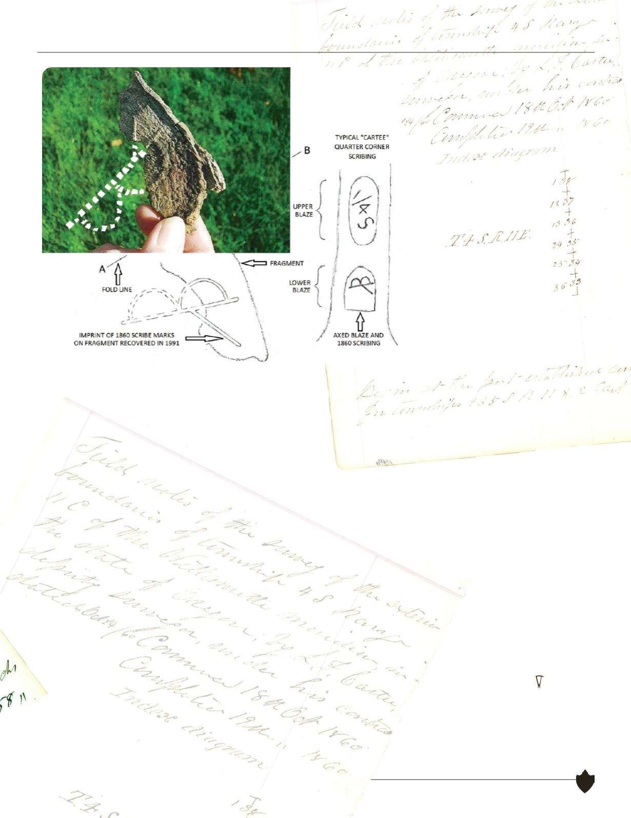
one remaining curly fragment and turning it over
revealed a clear imprint of a portion of Cartee’s
unique 1860 scribing of the letters “BT” with
his trademark “T” utilizing the straight line
of the “B” as its top. It is amazing to me that
this little fragment of white oak, that hadn’t seen
the light of day for 131 years, was the only evidence
remaining of the 1860 scribed blaze that had long
since rotted away. Much of the credit for this corner
recovery should go to Dave Simes, my instrument
man, who located several “stump patterns” matching
the 1860 geometry and drew my attention to them
on the steep, rocky hillside. After establishing the true
corner position at record bearing and distance from
the recovered 1860 BT, we then found the rotted stub
of the other Oak BT at its proper location. The 1969
BLM brass cap was about 4.5 feet, N 60 W from the
actual corner position. After I notified their Portland
office, the BLM surveyors examined the evidence
and remonumented both this corner and the east
quarter corner of Section 36, and then resurveyed
the east line of section 24. On July 31, 1991, Wayne
Gardner, Chief Cadastral Surveyor of Oregon, filed
a “corrective dependent resurvey of a portion of the
east boundary, T. 4 S., R. 11 E., Willamette Meridian,
Oregon, designed to restore the corners in their true
original locations according to the best available
evidence.” Thus we ended a very pleasant springtime
outing in the wilds of the Wy’East country.
The underside of the “curly” wood
fragment revealing an imprint of Carlee’s
trademark “BT.”
Professional Land Surveyors of Oregon
|
www.plso.org